TTCM
()
> Weather
—
Saturday,
May 4, 2024
—
W1
W2
W3
W4
W5
—
53°F
Washington, D.C., Weather
—
Sunrise: 6:07 (W1: 20%);
Solar Noon: 1:05 (W3: 52%);
Sunset: 8:03 (W5: 85%)
60
60
60
59
58
57
57
57
56
57
57
57
57
58
58
59
60
63
69
73
77
80
82
83
Last 72 Hours: Observations
—
Currently: 53°F
—
 —
Heavens-Above
—
Heavens-Above
54
53
53
54
54
54
54
56
56
56
58
58
58
58
59
59
57
56
56
54
54
54
54
54
54
54
54
54
56
58
60
62
63
64
66
68
70
71
71
70
68
67
65
64
64
64
64
64
...THE WASHINGTON NATIONAL DC CLIMATE SUMMARY FOR MAY 3 2024...

WEATHER ITEM   OBSERVED TIME   RECORD YEAR NORMAL DEPARTURE LAST
                VALUE   (LST)  VALUE       VALUE  FROM      YEAR
                                                  NORMAL
TEMPERATURE (F)
 TODAY
  MAXIMUM         76  12:01 PM  91    1965  74      2       58
  MINIMUM         67   6:44 AM  36    1909  54     13       48
  AVERAGE         72                        64      8       53

PRECIPITATION (IN)
  TODAY            0.00          2.41 1936   0.13  -0.13     0.01
  MONTH TO DATE    0.00                      0.37  -0.37     0.01
  SINCE MAR 1      6.95                      7.08  -0.13     5.16
  SINCE JAN 1     14.24                     12.56   1.68     8.89
Refresh
Coastal Flood Advisory
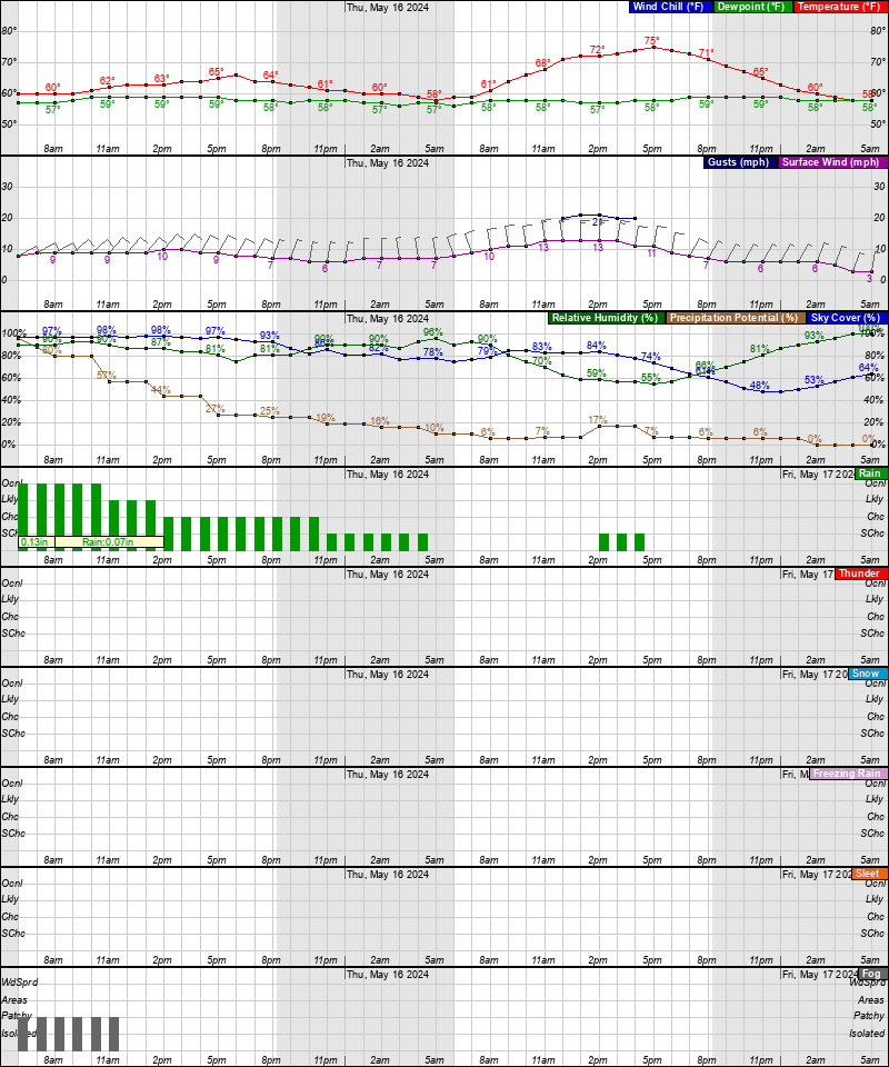
Tonight: Scattered showers and thunderstorms between 9pm and 2am, then showers likely and possibly a thunderstorm after 2am. Mostly cloudy, with a low around 53°. East wind 6 to 10 mph, with gusts as high as 21 mph. Chance of precipitation is 60%. New rainfall amounts of less than a tenth of an inch, except higher amounts possible in thunderstorms.
Saturday: Rain with areas of drizzle, mainly before noon, then rain after noon. High near 59°. East wind 7 to 9 mph. Chance of precipitation is 80%. New precipitation amounts between a tenth and quarter of an inch possible.
Saturday Night: Rain. Low around 55°. East wind around 8 mph. Chance of precipitation is 90%. New precipitation amounts between a tenth and quarter of an inch possible.
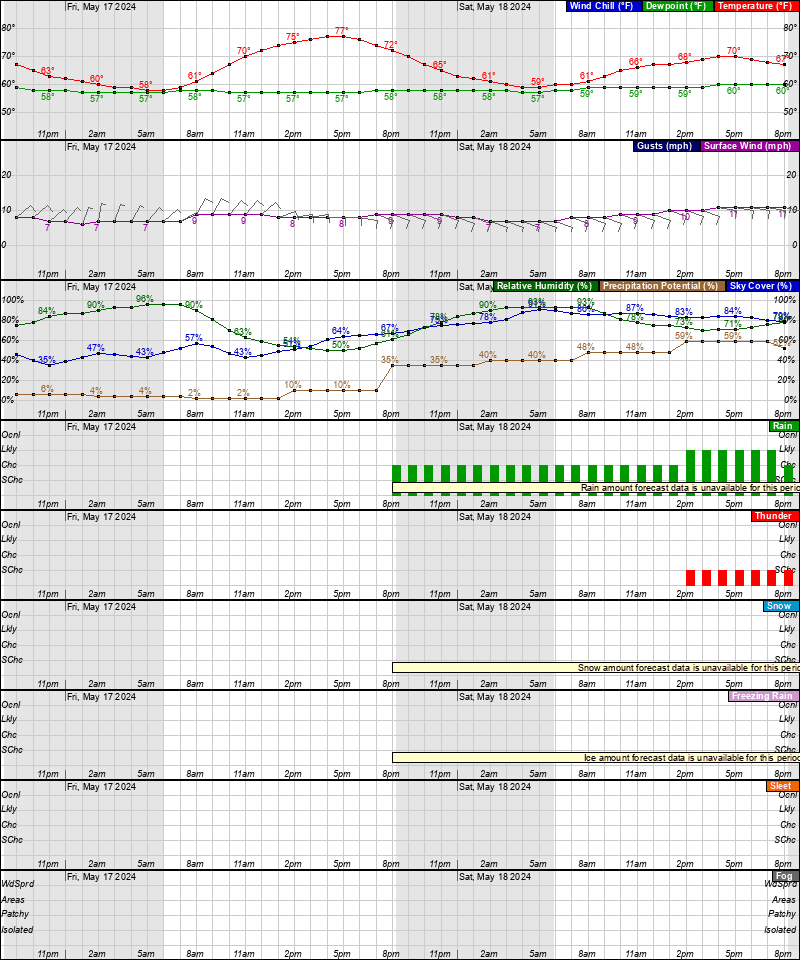
Sunday: Showers, with thunderstorms also possible after 5pm. High near 70°. South wind 8 to 10 mph. Chance of precipitation is 80%. New rainfall amounts between a quarter and half of an inch possible.
Sunday Night: Showers likely and possibly a thunderstorm. Cloudy, with a low around 63°. South wind 6 to 8 mph. Chance of precipitation is 60%.
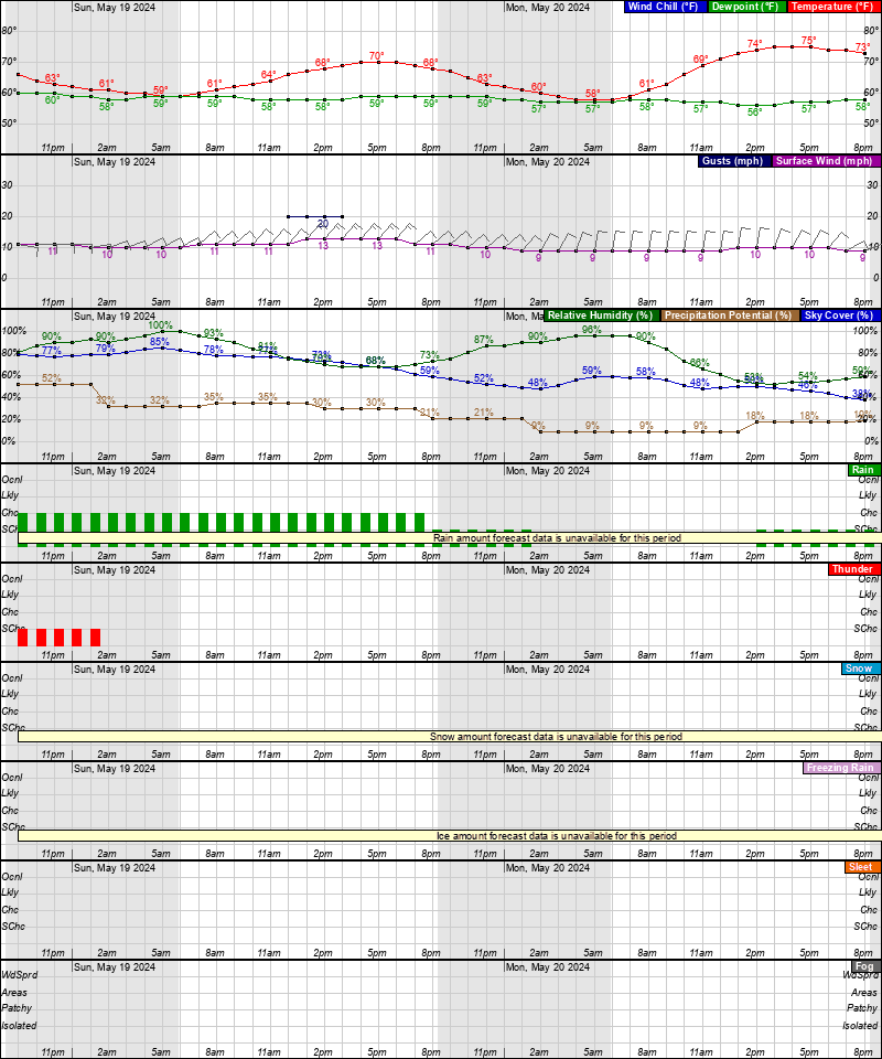
Monday: A chance of showers before 11am, then a chance of showers and thunderstorms between 11am and 2pm, then showers likely and possibly a thunderstorm after 2pm. Mostly cloudy, with a high near 80°. Chance of precipitation is 60%.
Monday Night: Showers likely and possibly a thunderstorm before 8pm, then a chance of showers and thunderstorms between 8pm and 2am, then a chance of showers after 2am. Mostly cloudy, with a low around 64°. Chance of precipitation is 60%.
Tuesday: A chance of showers. Partly sunny, with a high near 81°. Chance of precipitation is 50%.
Tuesday Night: A chance of showers before 2am. Mostly cloudy, with a low around 65°. Chance of precipitation is 30%.
Wednesday: A chance of showers and thunderstorms after 2pm. Partly sunny, with a high near 86°. Chance of precipitation is 40%.
Wednesday Night: A chance of showers and thunderstorms. Mostly cloudy, with a low around 66°. Chance of precipitation is 40%.
Thursday: Showers likely and possibly a thunderstorm. Mostly cloudy, with a high near 85°. Chance of precipitation is 70%.
Thursday Night: Showers and thunderstorms likely. Partly cloudy, with a low around 64°. Chance of precipitation is 60%.
Friday: A chance of showers and thunderstorms. Partly sunny, with a high near 77°. Chance of precipitation is 40%.
Latest Forecast
Time and Date:
Today,
Sun-Moon,
Climate-Forecast
—
Light
ISS Sightings
—
Space Dashboard
Launch Calendars:
NASA,
KSC,
2019,
SFN,
SFI,
RLL,
SpaceX
Weather Prediction Center
•
Storm Prediction Center
•
Climate Prediction Center


Area Forecast Discussion
National Weather Service Baltimore MD/Washington DC
249 PM EDT Fri May 3 2024
.SYNOPSIS...
A backdoor cold front will sink south of the area tonight. The
boundary will return north as a warm front Sunday into Monday
before secondary cold front approaches and stalls near the area
for the middle and latter portions of next week.
.NEAR TERM /UNTIL 6 AM SATURDAY MORNING/...
High pressure remains centered over the New England Coast this
afternoon while an upper-level ridge axis is slowly moving off
to our east. An upper-level trough is building over the central
CONUS and a backdoor cold front is currently located near the
Potomac Highlands into central Virginia.
The backdoor boundary will most likely stall out near the area
through late this afternoon before eventually pushing off to
our south and west tonight as high pressure strengthens along
the New England Coast.
As convergence strengthens along the backdoor boundary into this
evening, this will combine with moisture advection (southerly
flow aloft around periphery of the high) and instability,
triggering some showers and thunderstorms over the Allegheny
and Potomac Highlands into the Shenandoah Valley. This activity
will likely advect eastward into the metro areas late this
evening and overnight. A rumble of thunder is possible overnight
as well due to limited elevated instability above the marine
layer.
Low clouds and noticeably cooler conditions are expected
overnight as the onshore flow continues behind the backdoor
cold front. Lows will be in the 50s for most areas, with upper
40s in portions of northern Maryland.
.SHORT TERM /6 AM SATURDAY MORNING THROUGH SUNDAY NIGHT/...
The backdoor boundary will remain to the south and west through
Saturday night while high pressure remains centered near the New
England Coast. An onshore flow will continue during this time
while warm and moist air overruns the marine layer in response
to an upper-level trough pushing into the Midwest. This will
result in plenty of clouds along with periods of rainfall and
unseasonably cool conditions. There may be some breaks in the
rain, but for most of the time near and west of Interstate 95,
there will be some rain around. Perhaps there will be some more
breaks east of Interstate 95 where the overrunning moisture may
not be quite as deep.
The overrunning moisture will deepen Saturday night into Sunday
morning as the boundary begins to push north as a warm front,
and the low-level flow develops a fetch from the Gulf of Mexico.
Therefore, more rain is expected.
The warm front will move into the area Sunday while a weak
upper-level trough axis passes through. More unsettled
conditions are expected with showers and perhaps even a couple
thunderstorms. Sunday afternoon will turn out a bit warmer and
more humid as well, but temps still near and below climo. Highs
will range from the 60s north of the boundary in northern MD
into the metro areas/eastern WV/northern VA to the 70s south of
the boundary. The upper-level trough axis will move off to the
east Sunday night while the surface boundary remains nearby.
While a few showers are possible, coverage of precipitation
should wane behind the departing trough axis. There may be areas
of dense fog overnight with plenty of low-level moisture and
light winds.
.LONG TERM /MONDAY THROUGH FRIDAY/...
The unsettled weather pattern is likely to continue across the
region for virtually all of next week. Nearly zonal flow aloft
favors numerous passing shortwaves that bring enhancements to the
daily afternoon showers and thunderstorms. Even at night, isolated
showers/storms are possible given the increased moisture and
lingering elevated instability.
At the surface, a stalled frontal boundary is likely to be just
north of the area Monday, slide south to around I-70 Monday night,
then be pushed back north of the area through mid week. However, any
change in the position of the stalled front could result in higher
or lower rain chances than currently forecast for some areas. A
stronger shortwave trough is forecast to cross the area Wednesday
night into Thursday, possibly bringing some heavier rainfall and
stronger storms to the area.
Afternoon highs in the upper 70s to low 80s Monday and Tuesday warm
to the mid 80s Wednesday and Thursday. Very mild overnight lows in
the 60s each night due to increased dew points and cloud cover.
Latest Discussion
- Climate — Genesis 8:22
- While the earth remains, seedtime and harvest, cold and heat, winter and summer, and day and night shall not cease.
- Sea Level — Job 38:8-11
- Who shut in the sea with doors, when it burst forth and issued from the womb; when I made the clouds its garment, and thick darkness its swaddling band; when I fixed My limit for it, and set bars and doors; when I said, ‘This far you may come, but no farther, and here your proud waves must stop!’
About